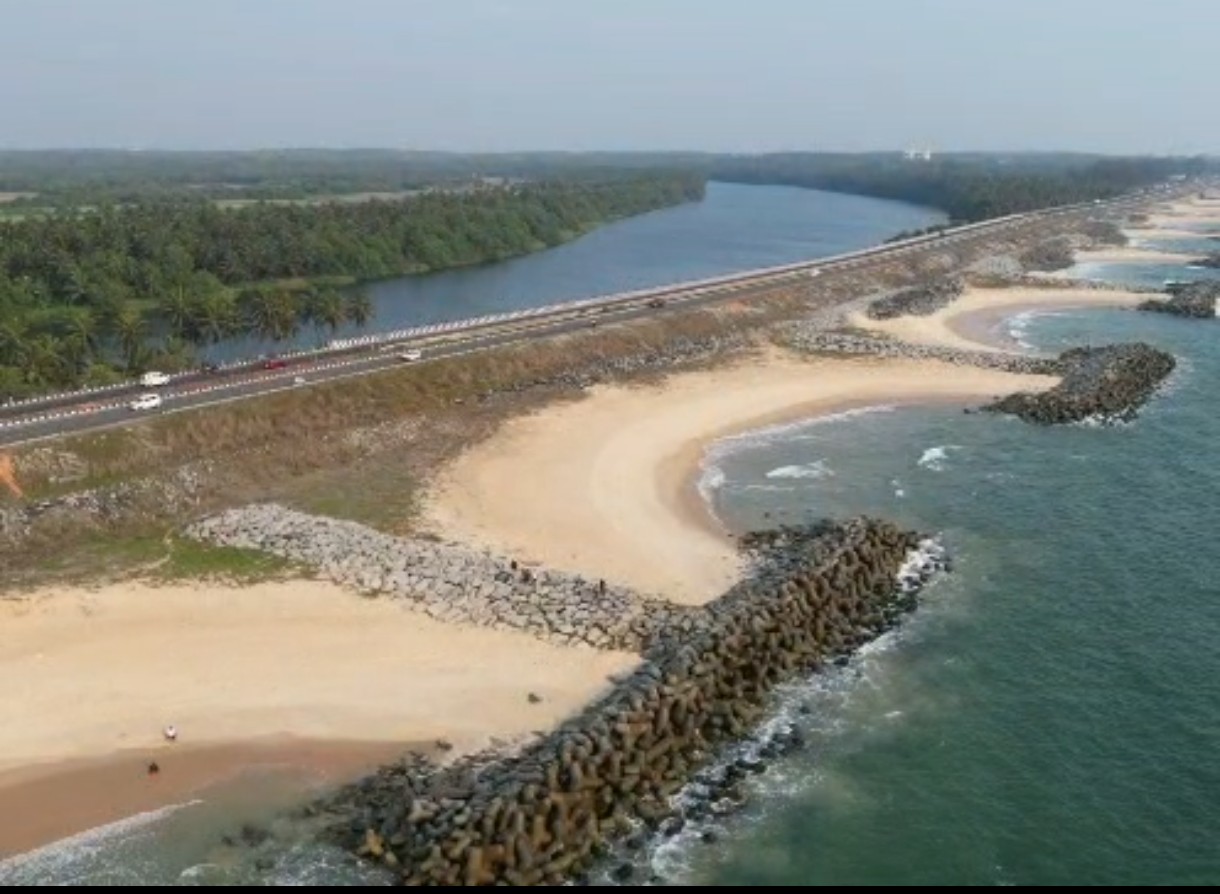
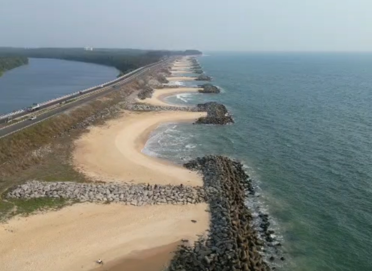
Maravanthe beach is a rare geographical marvel where the boundaries of the land seem to blur. It is famously defined by the National Highway 66, which acts as a slender bridge of asphalt separating two distinct bodies of water—the sprawling, rhythmic expanse of the Arabian Sea on one side and the calm, freshwater embrace of the Souparnika River on the other. This unique "coastal island" effect creates a mesmerizing drive where you are flanked by surf on your right and a tranquil backwater on your left. The beach itself is characterized by its long, expansive stretch of pristine golden sand, offering a vista that feels like a gateway between the ocean's raw power and the river's serene stillness.
ಉಡುಪಿ ಜಿಲ್ಲೆಯ ಬೈಂದೂರು ತಾಲ್ಲೂಕಿನಲ್ಲಿರುವ ಮರವಂತೆ ಬೀಚ್ ಕರಾವಳಿ ಕರ್ನಾಟಕದ ಅತ್ಯಂತ ವಿಶಿಷ್ಟ ಹಾಗೂ ಜಗತ್ಪ್ರಸಿದ್ಧ ಕಡಲತೀರಗಳಲ್ಲಿ ಒಂದಾಗಿದೆ. ಈ ಬೀಚ್ನ ವಿಶೇಷತೆಯೆಂದರೆ, ಒಂದು ಬದಿಯಲ್ಲಿ ಅರೇಬಿಯನ್ ಸಮುದ್ರದ ವಿಶಾಲವಾದ ಅಲೆಗಳು ಅಪ್ಪಳಿಸುತ್ತಿದ್ದರೆ, ಮತ್ತೊಂದು ಬದಿಯಲ್ಲಿ ಶಾಂತವಾಗಿ ಹರಿಯುವ ಸೌಪರ್ಣಿಕಾ ನದಿಯ ದೃಶ್ಯವು ಕಣ್ಣಿಗೆ ರಮ್ಯವಾದ ಅನುಭವವನ್ನು ನೀಡುತ್ತದೆ. ಈ ಎರಡೂ ಜಲಮೂಲಗಳ ಮಧ್ಯೆ ರಾಷ್ಟ್ರೀಯ ಹೆದ್ದಾರಿ (NH 66) ಹಾದುಹೋಗುವುದು ಪ್ರವಾಸಿಗರನ್ನು ವಿಶೇಷವಾಗಿ ಆಕರ್ಷಿಸುತ್ತದೆ.
ಪ್ರಕೃತಿ ಪ್ರೇಮಿಗಳು ಮತ್ತು ಛಾಯಾಗ್ರಾಹಕರಿಗೆ (Photographers) ಇದು ಅತ್ಯಂತ ನೆಚ್ಚಿನ ತಾಣವಾಗಿದ್ದು, ಸಂಜೆಯ ವೇಳೆ ಇಲ್ಲಿ ಸೂರ್ಯಾಸ್ತವಾಗುವ ನೈಸರ್ಗಿಕ ದೃಶ್ಯವು ಕಣ್ಮನ ಸೆಳೆಯುತ್ತದೆ. ಯಾವುದೇ ದೊಡ್ಡ ಮಟ್ಟದ ವಾಣಿಜ್ಯ ಮಳಿಗೆಗಳ ಹಾವಳಿಯಿಲ್ಲದೆ, ನೈಸರ್ಗಿಕ ಸೌಂದರ್ಯ ಹಾಗೂ ಪ್ರಶಾಂತ ವಾತಾವರಣವನ್ನು ಸವಿಯಲು ಬಯಸುವವರಿಗೆ ಮರವಂತೆ ಬೀಚ್ ಅತ್ಯುತ್ತಮವಾದ ಪ್ರವಾಸಿ ತಾಣವಾಗಿದೆ.
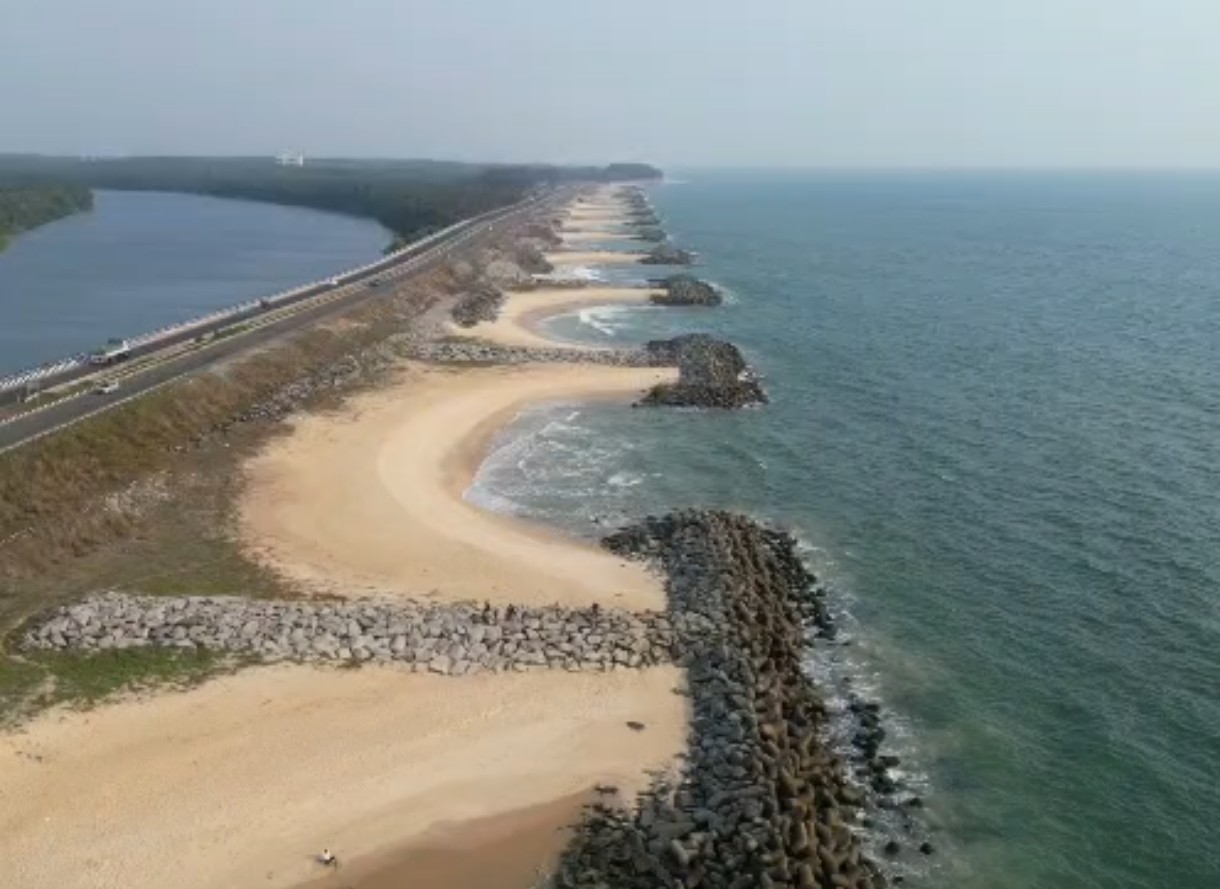
Maravanthe Beach is one of the most remarkable coastal places in Byndoor. What makes it special is not only the beach itself, but the unusual landscape around it. National Highway 66 passes through a narrow stretch of land with the Arabian Sea on one side and the Souparnika River on the other. As you travel along this road, you can see the sea and river almost together, creating a view that is rarely found along the Karnataka coast.
The first thing most visitors notice at Maravanthe is the way the landscape is arranged. On the western side, the Arabian Sea stretches along the coastline, while the Souparnika flows on the opposite side of the highway.
The river comes down from the Western Ghats and reaches the Maravanthe area before turning away from the coast. It later continues its journey and joins the sea farther south. This unusual course is one of the main geographical features that gives Maravanthe its identity.
Maravanthe is one of those places where the journey itself is part of the attraction. While travelling on NH66, the scenery keeps changing between the open sea, sandy shore, river, coconut trees and the green landscape beyond.
The stretch is especially beautiful when viewed during the early morning or late afternoon, when the light gives the sea and river a different appearance.
Although Maravanthe is a coastal destination, the Western Ghats are very much part of its scenery. The Kodachadri hill region lies inland, forming a green backdrop to the Souparnika side of the landscape.
This creates a striking contrast between the open Arabian Sea and the greener, quieter river landscape on the other side of the road.
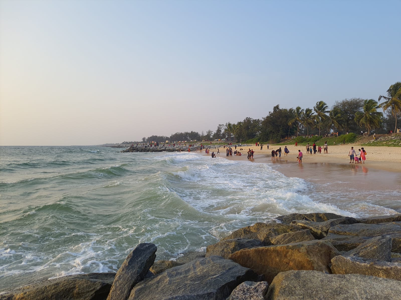
The shoreline at Maravanthe extends as a long sandy coastal stretch facing the Arabian Sea. Some sections are quiet and open, making the beach suitable for walking, photography and simply spending time beside the sea.
Sea conditions can change with the season. During the monsoon, the waves can become particularly strong, so swimming should be avoided when the sea is rough.
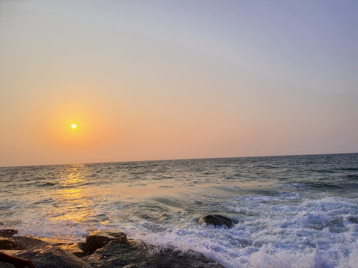
Evening is one of the best times to experience the beach. The sun sets over the Arabian Sea, and the changing colours of the sky are reflected across the coastal landscape.
The beach, sea and surrounding vegetation make Maravanthe a natural place for sunset photography, especially when the weather is clear.
The Souparnika is not just a backdrop to Maravanthe. It is an important river of the Byndoor region and has its own religious significance, particularly because of its association with Kollur Mookambika.
Near Maravanthe, however, the river takes on a different character. Its quieter waters and green banks provide a peaceful contrast to the waves and open horizon of the Arabian Sea.
Maravanthe also gives visitors a glimpse of everyday coastal life. The surrounding villages, coconut plantations, fishing activity and small local establishments are part of the landscape.
The area has not been transformed into a heavily built-up beach resort destination, which allows visitors to experience more of the natural coastal setting.
Maravanthe can easily be included in a wider Byndoor coastal journey. Trasi beach Park lies nearby, while the road towards Byndoor leads to places such as Ottinene, Someshwara Beach and other coastal viewpoints.
Travellers heading inland can also continue towards Kollur and the Mookambika Temple, making Maravanthe a convenient stop between the coast and the Western Ghats.
The months from October to March are generally comfortable for exploring the beach and surrounding areas. The monsoon transforms the landscape into a much greener setting, but the Arabian Sea can become rough and beach activities may be restricted by conditions.
Maravanthe is directly accessible through NH66, making it one of the easiest coastal destinations to visit by road in Byndoor. The beach is situated between the Kundapura and Byndoor sides of the coastal highway.
Maravanthe is not simply another sandy beach. Its real attraction is the rare combination of sea, river and highway within one narrow coastal landscape.
You can stand facing the Arabian Sea, turn around and find the Souparnika River on the other side of the road, with the greenery of the Western Ghats beyond it. That unusual setting is what makes Maravanthe one of the places that visitors remember long after travelling through Byndoor.
ಮರವಂತೆ ಬೀಚ್ – ಸಮುದ್ರ ಮತ್ತು ನದಿಯ ನಡುವೆ ಸಾಗುವ ಕರಾವಳಿ
ಮರವಂತೆ ಬೀಚ್ನ ವಿಶೇಷತೆ ಅದರ ಸಮುದ್ರ ತೀರಕ್ಕಿಂತಲೂ ಅದರ ಭೌಗೋಳಿಕ ವಿನ್ಯಾಸದಲ್ಲಿದೆ. ಒಂದು ಬದಿಯಲ್ಲಿ ಅರಬ್ಬಿ ಸಮುದ್ರ, ಮತ್ತೊಂದು ಬದಿಯಲ್ಲಿ ಸೌಪರ್ಣಿಕಾ ನದಿ — ಇವೆರಡರ ನಡುವೆ ರಾಷ್ಟ್ರೀಯ ಹೆದ್ದಾರಿ ಸಾಗುವ ದೃಶ್ಯ ಮರವಂತೆಯನ್ನು ಕರ್ನಾಟಕದ ಕರಾವಳಿಯಲ್ಲೇ ವಿಭಿನ್ನವಾಗಿಸುತ್ತದೆ. ಕೆಲವೆಡೆ ಸಮುದ್ರದ ಅಲೆಗಳು ಕಾಣುತ್ತಿದ್ದರೆ, ರಸ್ತೆ ಇನ್ನೊಂದು ಬದಿಯಲ್ಲಿ ನದಿಯ ನೀರು, ಹಸಿರು ಪ್ರದೇಶ ಮತ್ತು ತೆಂಗಿನ ಮರಗಳ ಸಾಲು ಕಾಣಿಸುವುದು ಇಲ್ಲಿನ ಪ್ರಮುಖ ದೃಶ್ಯ.
ಮರವಂತೆಯಲ್ಲಿ ಸಮುದ್ರ ಮತ್ತು ನದಿ ಬಹಳ ಹತ್ತಿರದಲ್ಲಿರುವುದರಿಂದ, ಒಂದೇ ಸ್ಥಳದಿಂದ ಎರಡು ವಿಭಿನ್ನ ಜಲಪ್ರದೇಶಗಳನ್ನು ನೋಡಬಹುದು. ಸೌಪರ್ಣಿಕಾ ನದಿ ಈ ಭಾಗದ ಕರಾವಳಿಗೆ ಸಮಾಂತರವಾಗಿ ಹರಿದು, ಮುಂದೆ ಅರಬ್ಬಿ ಸಮುದ್ರವನ್ನು ಸೇರುತ್ತದೆ. ಈ ನದಿ–ಸಮುದ್ರದ ವಿನ್ಯಾಸವೇ ಮರವಂತೆಯ ಗುರುತಾಗಿದೆ.
ಮರವಂತೆಯ ಮೂಲಕ ಸಾಗುವ ಹೆದ್ದಾರಿ ಈ ಸ್ಥಳದ ಅನುಭವವನ್ನು ಮತ್ತಷ್ಟು ವಿಶೇಷವಾಗಿಸುತ್ತದೆ. ಒಂದು ಬದಿಯಲ್ಲಿ ನೀಲಿ ಸಮುದ್ರ ಮತ್ತು ಉದ್ದವಾದ ಮರಳು ತೀರ, ಇನ್ನೊಂದು ಬದಿಯಲ್ಲಿ ಸೌಪರ್ಣಿಕಾ ನದಿ ಹಾಗೂ ಅದರ ಹಸಿರು ತೀರ — ಪ್ರಯಾಣಿಸುವಾಗಲೇ ಕಾಣುವ ಈ ದೃಶ್ಯ ಮರವಂತೆಯ ಪ್ರಮುಖ ಆಕರ್ಷಣೆ. ಅದಕ್ಕಾಗಿಯೇ ಮರವಂತೆ ಕರಾವಳಿ ರಸ್ತೆ ಪ್ರಯಾಣಕ್ಕೂ ಪ್ರಸಿದ್ಧವಾಗಿದೆ.
ಮರವಂತೆಯ ಇನ್ನೊಂದು ಮುಖ ಸೌಪರ್ಣಿಕಾ ನದಿ. ಸಮುದ್ರದ ಅಲೆಗಳಿಗಿಂತ ಭಿನ್ನವಾಗಿ ನದಿಯ ಭಾಗದಲ್ಲಿ ನೀರು ಮತ್ತು ಸುತ್ತಲಿನ ಪರಿಸರ ಹೆಚ್ಚು ನಿಶ್ಶಬ್ದವಾಗಿ ಕಾಣುತ್ತದೆ. ನದಿಯ ತೀರದ ಹಸಿರು, ತೆಂಗಿನ ಮರಗಳು ಮತ್ತು ಹಿನ್ನಲೆಯ ಬೆಟ್ಟಗಳ ದೃಶ್ಯ ಮರವಂತೆಯ ಕರಾವಳಿ ಸ್ವರೂಪಕ್ಕೆ ಮತ್ತೊಂದು ಆಯಾಮ ನೀಡುತ್ತದೆ.
ಸ್ವಚ್ಛವಾದ ದಿನಗಳಲ್ಲಿ ಮರವಂತೆಯ ಸುತ್ತಮುತ್ತಲಿನ ದೃಶ್ಯದಲ್ಲಿ ಕೊಡಚಾದ್ರಿ ಬೆಟ್ಟಗಳ ಹಿನ್ನಲೆಯೂ ಕಾಣಿಸಿಕೊಳ್ಳುತ್ತದೆ. ಸಮುದ್ರ, ನದಿ, ಕರಾವಳಿ ಸಸ್ಯವರ್ಗ ಮತ್ತು ದೂರದ ಬೆಟ್ಟಗಳು ಒಂದೇ ದೃಶ್ಯದಲ್ಲಿ ಸೇರುವುದರಿಂದ ಮರವಂತೆ ಛಾಯಾಗ್ರಹಣಕ್ಕೆ ವಿಶೇಷವಾದ ಸ್ಥಳವಾಗಿದೆ.
ಸಂಜೆಯ ವೇಳೆಯಲ್ಲಿ ಮರವಂತೆಯ ದೃಶ್ಯ ಇನ್ನಷ್ಟು ಬದಲಾಗುತ್ತದೆ. ಸೂರ್ಯ ಸಮುದ್ರದ ಕಡೆ ಇಳಿಯುವ ಸಮಯದಲ್ಲಿ ಆಕಾಶದ ಬಣ್ಣಗಳು ಸಮುದ್ರದ ನೀರಿನ ಮೇಲೆ ಪ್ರತಿಬಿಂಬಿಸುತ್ತವೆ. ನದಿ ಮತ್ತು ಸಮುದ್ರ ಎರಡೂ ಒಂದೇ ಪ್ರದೇಶದಲ್ಲಿ ಕಾಣಿಸುವುದರಿಂದ ಸೂರ್ಯಾಸ್ತದ ಸಮಯದಲ್ಲಿ ಇಲ್ಲಿನ ದೃಶ್ಯ ವಿಶೇಷವಾಗಿ ಗಮನ ಸೆಳೆಯುತ್ತದೆ.
ಮರವಂತೆ ಸುತ್ತಮುತ್ತಲಿನ ಪ್ರದೇಶದಲ್ಲಿ ತೆಂಗು, ಗೋಡಂಬಿ, ಹಲಸು ಮತ್ತು ಮಾವಿನ ತೋಟಗಳು ಕಾಣಿಸುತ್ತವೆ. ಸಮೀಪದ ಕರಾವಳಿ ಗ್ರಾಮಗಳಲ್ಲಿ ಮೀನುಗಾರಿಕೆ ಕೂಡ ಸ್ಥಳೀಯ ಜೀವನದ ಒಂದು ಭಾಗವಾಗಿದೆ. ಹೀಗಾಗಿ ಮರವಂತೆ ಕೇವಲ ಪ್ರವಾಸಿಗರು ಭೇಟಿ ನೀಡುವ ಬೀಚ್ ಅಲ್ಲ; ಕರಾವಳಿಯ ನೈಸರ್ಗಿಕ ಪರಿಸರ ಮತ್ತು ಸ್ಥಳೀಯ ಜೀವನ ಎರಡನ್ನೂ ಒಂದೇ ಪ್ರದೇಶದಲ್ಲಿ ಕಾಣಬಹುದಾದ ಸ್ಥಳವಾಗಿದೆ.
ಕರ್ನಾಟಕದ ಅನೇಕ ಬೀಚ್ಗಳಲ್ಲಿ ಸಮುದ್ರವೇ ಪ್ರಮುಖ ಆಕರ್ಷಣೆಯಾಗಿದ್ದರೆ, ಮರವಂತೆಯಲ್ಲಿ ಸಮುದ್ರ + ಸೌಪರ್ಣಿಕಾ ನದಿ + ಹೆದ್ದಾರಿ + ಬೆಟ್ಟಗಳ ಹಿನ್ನಲೆ ಒಂದೇ ದೃಶ್ಯದಲ್ಲಿ ಸೇರುತ್ತವೆ. ಈ ಅಪರೂಪದ ವಿನ್ಯಾಸವೇ ಮರವಂತೆ ಬೀಚ್ಗೆ ತನ್ನದೇ ಆದ ಗುರುತನ್ನು ನೀಡಿದೆ.
🚗 By road: Beside NH66
🚌 By bus: Frequent private and govt buses from Kundapura Byndoor
🚆 By train: Nearest Railway Station Senapura Railway Station about 9km (local) and Byndoor Mookambika Road Railway Station about 21 km (express).
✈️ By air: Mangalore International Airport about 110km
| Nearest ATM | Trasi |
|---|---|
| Restrooms | Not available |
Places usually visited on the same trip.